Take Action Now:
The Moolarben Underground 4 Mine (UG4) is the biggest threat yet to The Drip gorge and Goulburn River. Longwall mining risks destabilising this iconic area
— unless we act now! See below for more detailed information.
✅ Demand a 2km buffer zone between mining and the river gorges
✅ Shorten longwalls to prevent further harm
Final decisions are being made NOW. Send a quick message to NSW Ministers:
New Extraction Plan Underground 4 (UG4)
In 2007 the very large Yancoal/Moolarben Mine Stage 1 was approved to allow underground mining operations within 200 metres of the Goulburn River and surrounding fragile sandstone cliffs and gorges. The project threatens key cultural landmarks including the iconic natural feature known as The Drip, sacred Wiradjuri women's places and an original Brett Whiteley rock painting created in the 1970s by Brett and his daughter Arkie under a sandstone overhang.
The Conditions of Approval for the underground mine require:
- “nil impact to The Drip water supply” and
- "Negligible impact or environmental consequences on the Goulburn River.”
However, once the damage is done it is irreversible. Mining within 2 kilometres of this sensitive reach of the Goulburn River is an unacceptable risk.
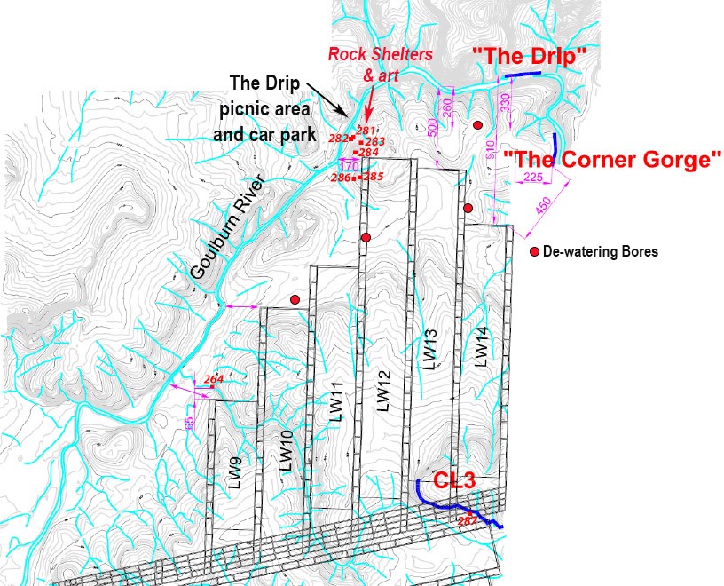
Yancoal is already mining the first 8 longwall panels in Undergound 4 and has lodged an Extraction Plan with the Department of Planning for the remaining 9 -14 panels, closest to the Goulburn River corridor, due to commence within 1 -3 years.
This represents the greatest mining threat so far to integrity and stability of The Drip gorge and Goulburn River.
Key threats from this underground mining within 100 meters of the river banks and fragile sandstone cliffs and gorges:
- Collapsed longwall tunnels have caused far field movements of the earth surface up to 2 kms
- Subsidence could destabilise the fragile sandstone landscape in and around sensitive areas of Goulburn River National Park, making The Drip walking track and river area unsafe for recreational and visitor use
- Underground mining risks fracturing and draining the upper aquifers (groundwater) that flow to the Gouburn River, removing critical base flows in times of drought
- Potential to crack the river and reverse surface and groundwater flow into the mine
- The Brett Whiteley mural on The Drip walk is currently managed by Goulburn River National Park. However, Yancoal’s new extraction plan (Moolarben UG4) comes within 100m of the river and could destabilise the area to a point where public access would be removed for safety. The mines approval requires ‘nil impacts’ on The Drip gorge. To achieve this, a 2km buffer would be needed.
The Independent Expert Advisory Panel for Mining (IEAPM) recommended water monitoring bores to collect base line information in preparation for this next mining phase. Yancoal has only just installed these and does not have sufficient information to include in the Extraction Plan that has been lodged for approval.
The five 1-2 km longwall panels are to be extracted starting at the closest point to the River corridor - any damage will be irreversible and occur at the beginning of mining.
Any "legal fine" could not cover the loss of this iconic natural landscape, loved by many.
Mining within 2 kilometres of the Goulburn River is an unacceptable risk.
The Drip Gorge is a significant place for the local Wiradjuri People and should be protected.


Pells Report
Engineering Consultants
Sue Higginson
Greens MLC
What is an Extraction Plan?
An extraction plan is used to manage subsidence associated with underground coal mining and is prepared after development consent is given. It’s not created to support the environmental impact assessment process or to obtain consent. The plan is primarily an operational document used by mining companies and regulators to ensure compliance and provide transparency to the community.
It cannot expand the mining area or propose any activities that increase subsidence or environmental impacts beyond what is approved. The plan describes how operations will be carried out, monitored, managed, and reported. While the plan may reduce mining intensity or impacts, it cannot lower impacts beyond what’s permitted. Any changes to the approved operations require a modification application.

Take Action Now
Local Mines