Key concerns with Ulan Mod 8 mine expansion:
- Extends Coal Mining:
- Seeks to extend thermal coal mining for a further six years (to 2041), extracting an additional 43 million tonnes of coal
- Minimises cumulative impacts of coal mining that straddles the Great-Dividing-Range affecting two major catchments Murray-Darling Basin & Hunter River
- Climate Impact:
- Would add 105 Mt CO2-e of Scope 3 emissions, an additional 45% on the currently approved operations (including Modification 6)
- Water & Groundwater Damage:
- Reduces base flows to Talbragar River, threatening Macquarie Marshes (Ramsar-listed wetland) and Goulburn-Hunter catchment
- Will export over 15,000 tonne salt loads to the Goulburn and Hunter River system by extending Mine water discharge six years
- Plan to significantly increase toxic tailings dam infrastructure to the river edge (132 ha area), risking seepage to river flow and downstream Goulburn River National Park and The Drip Gorge ecosystem
- Biodiversity Loss:
- The project will impact 101.45ha of native vegetation, including 34ha of Box Gum Woodland
- Threatened Species:
- It will affect habitats of endangered species, including the Large-Eared Pied Bat and Eastern Cave Bat
- Direct impacts on critically endangered Regent Honeyeater (habitat in Mudgee-Wollar Key Biodiversity Area)
- Risks to Koala, Brush-tailed Rock Wallaby
- Cultural Heritage Risk:
- Project is on Wiradjuri Country subject to a Native Title Claim and will impact 71 known Aboriginal sites
- The area holds cultural significance for the Wiradjuri people
- This is a flawed approval process that should be assessed as a New Project – not a Modification, that removes scrutiny by the Independent Expert Panel for Mining
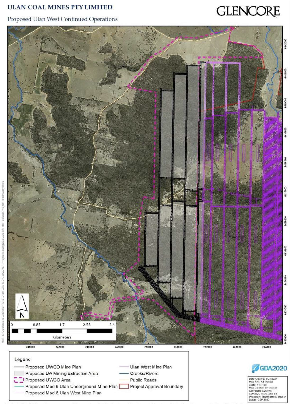
Glencore’s Ulan West Modification 8
The modification application for the Ulan West Modification 8 exhibition period has now closed. Exploration in areas EL 8687 and EL 9363 has been assessed as part of the Ulan West Continuation Project, which involves an additional 7 underground longwall panels extending westward. These panels are predicted to produce approximately 38 million tonnes of coal, with operations continuing until 2041.
There are significant potential impacts on water resources, biodiversity, Aboriginal cultural heritage, and the local community. Many small farms and properties in the area depend on springs and a high water table, which are already under pressure from groundwater drawdown due to ongoing Ulan Mine operations.
The justification for this expansion is very poor. Although Ulan Mine has approval to extract up to 20 million tonnes of coal annually until 2035, it only managed to extract 9.29 million tonnes in 2024. The promised public benefits — such as royalties and economic contributions — are not being met, while the environmental, social, and cultural costs continue to escalate.
- Impact the Murray–Darling basin, the backbone of Australia's agriculture industry
- Impact 1,734 ha including 191 ha of vegetation clearing.
- Undermine 6.5km of rugged sandstone escarpment.
- Create cumulative impacts on the Talbragar and Goulburn Rivers through groundwater and surface water interception.
Agency Advice:
1. Water Assessment:
NSW DCCEEW Water Group has reviewed the Modification Report and has significant concerns regarding risks to water sources and dependent ecosystems. This is due to:
- Connective fracturing to surface and enhanced aquifer stream connectivity
- Drawdown impacts on groundwater dependent ecosystems and water users, and
- The potential for long-term water quality impacts to watercourses
2. EPA Assessment:
The EPA has reviewed the EIS and notes that it does not provide the information required to complete the assessment as:
- More information is required on the tailings Storage Dam
- An alternative location should be proposed for the tailings storage facility (TSF) to avoid seepage pathways to the Goulburn River alluvium
- A Review and update on the greenhouse gas emissions estimates needs to be made, and
- Sufficient details need to be provided, including all assumptions, methodologies, and input data, to enable replication of the greenhouse gas emissions estimates
3. Biodiversity Assessment:
Conservation Programs, Heritage and Regulation Group (CPHR) has reviewed the Modification Report and Biodiversity Development Assessment Report (BDAR) and considers that:
- The BDAR is likely to underestimate the biodiversity impacts of the proposed modification, and
- The modificaiton is therefore not compliant with the Biodiversity Assessment Method (BAM)
- The assessment of prescribed and indirect impacts associated with subsidence requires further review, and
- Evidence stated in the BDAR & CPHR does not support the credit calculation for subsidence impacts on threatened micro bat habitat
Ulan Coal (UWCO) Modification 8 – Information on Tailings Dam
High risk placement of Tailings Dam: Expands toxic waste storage adjacent to the Goulburn River, risking seepage downstream into the National Park.
The Ulan West Continued Operations (UWCO) Modification proposes the construction of 132 hectare new tailings disposal area (with associated overburden stockpiles) to be built within an old open-cut pit that has been partially rehabilitated and revegetated with native trees, plantings date back to before 2000. The proposed boundary (red line) of the tailings disposal area goes to the edge of the Goulburn River. The old rehabilitated pit – Ulan Open Cut -1 - was backfilled in the 1990s with coal rejects and overburden.
UlanCoal has provided no details on how this significant infrastructure will be constructed, how it will be lined to stop seepage of toxic groundwater, how it will be managed or monitored for groundwater leakage to avoid contamination of the river over 100s of years, post mining.
It introduces a dangerous and toxic legacy to this landscape risking the long-term river health and viability of the Goulburn and Hunter River ecosystems.
Figure A – This shows an enlarged section of the ‘Proposed UWCO Modification’ from Figure 1.3 UWCO Modification Report. The background is an out-of-date aerial map that misrepresents the current mine layout
The stated rational for the location of the proposed tailings storage facility to ‘minimise impacts’ is based on assumptions and unsubstantiated claims to be…. ‘feasibly practicable’.
There is no information on what investigations were undertaken to confirm substrate characteristics, and groundwater levels, where excavated overburden will be placed, or what alternate sites were considered? Surface Water (App 7) refers to a report by Aurecon (2025) but there is no link to this reference.
The Soils, Land and Agriculture Report (p.29) states it did not assess the proposed 131 ha new infrastructure Tailings disposal Area.
